Natural Prioritizing Conservation Project ImplementationProjects with Partners
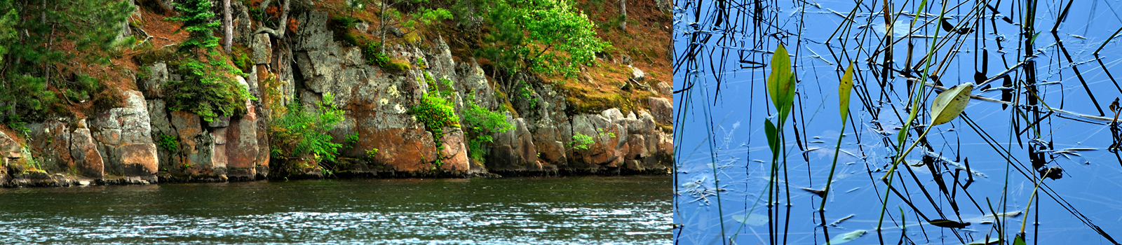
Minnesota Traditions

In 2016 the MHB created a campaign to prevent the spread of aquatic invasive species (zebra mussels, Eurasian watermilfoil). Thirty minute infomercials were created and aired on Fox Sports North and a social media campaign named Minnesota Traditions was launched to help educate and change Minnesotan’s behavior when they recreate in our lakes, rivers, and streams. Throughout the campaign, many different media were used to educate the user, but the social media campaign seemed to be the most successful strategy to reach people and change behavior. Today the social media program reached millions of Minnesotans on Facebook and Twitter to implement Clean, Drain, & Dry techniques at the boat launches, and Dispose of bait properly. This program complements the local county inspectors at the boat accesses and the resource messaging can be found on this website at: MHB Education
Resource Documents: Stormwater Reports
In 2014 and 2015 the MHB received Clean Water Fund grants from the Board of Water and Soil Resources to help identify and rank stormwater pollution priorities in 12 cities. This innovative study was new at the time because it studied stormwater pollutants and developed a prioritization methodology at a regional level. This methodology lead Soil & Water Conservation District to successfully compete and receive implementation grants to help protect pollutants from entering the Mississippi River.
- Cumulative BMP Study Cumulative BMP Study
- A - BemidjiA - Bemidji
- Irving Feasibility studyIrving Feasibility study
- B - Cass LakeB - Cass Lake
- C - WalkerC - Walker
- D 1 - CohassetD 1 - Cohasset
- D 2 - Grand RapidsD 2 - Grand Rapids
- D 3 - La PrairieD 3 - La Prairie
- E- PallisadeE- Pallisade
- F - AitkinF - Aitkin
- G - RivertonG - Riverton
- H - Brainerd & BaxterH - Brainerd & Baxter
- 2020 Brainerd Stormwater Retrofit2020 Brainerd Stormwater Retrofit
- I - Little FallsI - Little Falls
MHB Strategic Plan
In 2020, the MHB board adopted a long range strategic plan to help protect the watersheds that drain to the Mississippi River. It strategic plan aligned our efforts with the One Watershed One Plan efforts being done in the MHB member counties. The document provided data to focus the efforts of organizations when implementing land protection programs (easements, fee-title acquisitions, and Sustainable Forest Incentive Practices). Below is a powerpoint that provides maps of the protection areas.
- MHB StrategyMHB Strategy
Mississippi Headwaters Habitat Corridor Program
In 2016, the Mississippi Headwaters Board developed a program in partnership with the Board of Water and Soil Resources and The Trust for Public Land to protect critical fish and wildlife habitat values on private land that lies on the Mississippi River, headwaters lakes and reservoirs, and contributing tributaries. The program uses Outdoor Heritage funds created from the Clean Water Land and Legacy constitutional amendment to create and expand contiguous habitat complexes of permanently protected shoreland.
- MHB Fact SheetMHB Fact Sheet
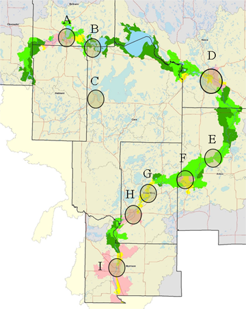
Resource Documents: Sub Watershed Prioritization Maps
In 2014, Implementation plans and methodologies were developed for the County Local Water Plan by the MHB through a Clean Water Fund grant in the 8 MHB member counties. The methodology measured risk by using GIS data and classified each watershed on the Mississippi River as a low risk to high risk based on the percent of public land and percent of disturbed land. It also identified key point source risks that enabled the implementer to identify and treat. The MHB board of commissioners used this methodology and adapted it into their local county water plans. Today this methodology is being used in the One Watershed One Plan program.
Mississippi River Water Plan Implementation Chapters/Catchment Maps (by County)
- AitkinAitkin
- BeltramiBeltrami
- CassCass
- Clearwater Clearwater
- Crow Wing County Crow Wing County
- Hubbard Hubbard
- Itasca Itasca
- Morrison Morrison
Mississippi River Water Plan Implementation Chapters/Catchment Maps (by County)
- CM1 - Itasca ParkCM1 - Itasca Park
- CM2 - N. of Itasca ParkCM2 - N. of Itasca Park
- CM3 - LaSalle LakeCM3 - LaSalle Lake
- CM4 - Beltrami-Hubbard-CWC- Bndy CM4 - Beltrami-Hubbard-CWC- Bndy
- CM5 - Beltrami-Hubbard-BndyCM5 - Beltrami-Hubbard-Bndy
- CM6 - Bemidji WestCM3 - LaSalle Lake
- CM7 - Bootleg CM7 - Bootleg
- CM8 - BemidjiCM8 - Bemidji
- CM9 - Stump LakeCM9 - Stump Lake
- CM10 - Wolf Andrusia LakesCM10 - Wolf Andrusia Lakes
- CM11 - Cass LakeCM11 - Cass Lake
- CM12 - East of Cass LakeCM12 - East of Cass Lake
- CM13 - WinniCM13 - Winni
- CM14 - East of WinnniCM14 - East of Winnni
- CM15 - White OakCM15 - White Oak
- CM16 - SchoolcraftCM16 - Schoolcraft
- CM17 - Little White OakCM17 - Little White Oak
- CM18 - Blackwater LakeCM18 - Blackwater Lake
- CM19 - Jay Gould LakeCM19 - Jay Gould Lake
- CM20 - Grand RapidsCM20 - Grand Rapids
- CM21 - La PrairieCM21 - La Prairie
- CM22 - South East of Grand RapidsCM22 - South East of Grand Rapids
- CM23 - West of WarbaCM23 - West of Warba
- CM24 - Itasca-Aitkin-BndyCM24 - Itasca-Aitkin-Bndy
- CM25 - Hwy 200 North of Aitkin CoCM25 - Hwy 200 North of Aitkin Co
- CM26 - Hwy 200 Swan River N. Aitkin CoCM26 - Hwy 200 Swan River N. Aitkin Co
- CM27 - Ltl Ball Bluff LakeCM27 - Ltl Ball Bluff Lake
- CM28 - Two Rivers SpringsCM28 - Two Rivers Springs
- CM29 - Libby BrookCM29 - Libby Brook
- CM30 - West of Big Sandy LakeCM30 - West of Big Sandy Lake
- CM31 - PalisadeCM31 - Palisade
- CM32 - Aitkin WMACM32 - Aitkin WMA
- CM33 - Diversion ChannelCM33 - Diversion Channel
- CM34 - NE of AitkinCM34 - NE of Aitkin
- CM35 - SE of AitkinCM35 - SE of Aitkin
- CM36 - NW of AitkinCM36 - NW of Aitkin
- CM37 - Aitkin CWC BndyCM37 - Aitkin CWC Bndy
- CM38 - Spruce Grove Rd.CM38 - Spruce Grove Rd.
- CM39 - Hwy 6 Cr 11CM39 - Hwy 6 Cr 11
- CM40 - Pine River and Fool LakeCM40 - Pine River and Fool Lake
- CM41 - South of Pine River ConfluenceCM41 - South of Pine River Confluence
- CM42 - Half MoonCM42 - Half Moon
- CM43 - Rice Lake Whiskey CreekCM43 - Rice Lake Whiskey Creek
- CM45 - Brainerd and BaxterCM45 - Brainerd and Baxter
- CM46 - Crow Wing State ParkCM46 - Crow Wing State Park
- CM47 - S. of CW State ParkCM47 - S. of CW State Park
- CM48 - Nokasippi ConfluenceCM48 - Nokasippi Confluence
- CM49 - Fort RipleyCM49 - Fort Ripley
- CM50 - Ripley TwpCM50 - Ripley Twp
- CM51 - Randall and C. RipleyCM51 - Randall and C. Ripley
- CM52 - West of Little FallsCM52 - West of Little Falls
- CM53 - Little FallsCM53 - Little Falls
- CM54 - South of Little FallsCM54 - South of Little Falls
- CM55 - Southwest of RoyaltonCM55 - Southwest of Royalton
- CM56 - BowlusCM56 - Bowlus
Mississippi River Water Plan Implementation Chapters/Catchment Maps (by County)
- B Summary SheetsB Summary Sheets
- Exceeding AUIDs by CountyExceeding AUIDs by County
- MHB Water Quality AnalysisMHB Water Quality Analysis
- RM Water QualityRM Water Quality