|

Spring Floods Likely
For The Mississippi Headwaters
River and emergency managers are preparing now for high water levels on the Mississippi River next month. They reported to the Cass County Board of Commissioners March 18, in Walker, on strategies to inform the public and minimize effects of high water.
Operators of the first five dams on the Mississippi River met in Walker February 14 to review weather forecasts and reservoir levels. The Mississippi Headwaters Board convened the meeting at the request of
the operators.
At that meeting, dam operators from Ottertail Power Company, the U.S. Forest Service, the U.S. Army Corps of Engineers and the Minnesota Department of Natural Resources discussed current dam operations, which include releasing water from reservoirs before snow melt begins.
State and county emergency managers discussed public notice about high water levels and how to help individuals manage high water conditions.
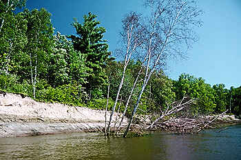
Lake and river managers discussed the aftermath of high water levels and agreed to identify sources of assistance for shoreland property owners managing erosion resulting from high water conditions. Leech Lake Reservation Tribal Council is also participating in the discussions and planning. The tribe manages river lands using a plan similar to the Mississippi Headwaters Board's. Protecting tribal treaty rights is a primary operating objective for the U.S. Army Corps of Engineers.
Preventing flooding at Aitkin is the Corps' objective. Manipulation of Leech Lake and Lake Winnibigoshish is critical. These reservoirs have the most storage in the Headwaters system. If Leech and Winnie can hold runoff from snow melt, downstream water levels can be minimized.
In February, Winnie was at the desired late winter level, according to Corps managers. Leech is high, and discharge has been occurring. Once snow melt begins, discharge will stop at Leech.
A few sunny days with temperatures reaching 40 degrees Fahrenheit will trigger snowmelt. In past years,
the first day with temperatures in the 40s has been as early as March 1 (1993) and as late as April 8th (1996).
By the end of mid-February, about 72 inches of snow has fallen, just short of last year's 81 inch total; and the first days of March brought more snow. Lots of snow does not necessarily mean high runoff at snow melt. Moisture content of the snow and of the soil are also factors. This snow has more water content than usual. The ground below is not deeply frozen and has significant moisture content from fall rains.
Information on water levels in the Mississippi and weather conditions are provided by George Rossman, retired publisher of the Grand Rapids Herald Review. Rossman has interpreted flow information on the six Headwaters reservoirs for many years. Contact him at grgv@azstarnet.com for current status of the reservoirs.
Last year, shoreland property owners on headwaters reservoirs Cass, Leech and Pokegama reported erosion and property damage due to high water levels. Property owners are urged to act now to minimize damage. If possible, docks and smaller structures should be moved away from shoreland areas. Sandbags are available from county emergency managers, who can be reached by calling the county sheriff.
Residents are also encouraged to investigate erosion control methods. Information about stabilization techniques are available from the Cass County Environmental Services Office, the Mississippi Headwaters Board, the Chippewa National Forest and the Corps. Any shoreland stabilization work done below the ordinary high water mark requires a permit from the Minnesota Department of Natural Resources. If more than 10 cubic yards of dirt is moved, a county permit may be required. Call 218- 547-7263 for information.
The U.S. Army Corps of Engineers has several programs to stabilize shorelands. Call the Headwaters District Office at 218-566-2306.
Geomorphological Data
Distributed To County Water Planners
The lay of the land can help determine how the land should be used to protect water quality, according to a research project funded in part by the Mississippi Headwaters Board.
Electronic maps of landforms created by glaciers and associated with surface water resources have been compiled in a digital form. The eight member counties of the Mississippi Headwaters Board will be receiving copies of this data in March. Cass County, for example, has used the information to guide wellhead protection and development of a local wetlands ordinance.
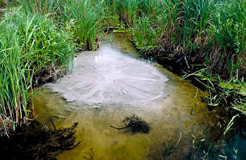
Landforms are defined as the combination of the lay of the land and the permeability of the soil. Landforms can be used to predict groundwater recharge and discharge, according to University of Minnesota Duluth hydrologist Howard Mooers. He directed a research project mapping landforms of the Itasca moraine and then investigated which landforms are associated with groundwater recharge and which are associated with groundwater discharge.
 Groundwater percolates through blue marl at the river's edge near the Clearwater-Beltrami County line.
Dr. Howard Mooers, University of Minnesota - Duluth - Geology Department, began mapping surface geological features of the Mississippi Headwaters region for the Board using funds appropriated by the 1993 Minnesota Legislature, as recommended by the Legislative Commission on Minnesota Resources.
During the MHB study, Dr. Mooers and his students used the maps to predict groundwater recharge in the Itasca moraine. Mooers theorized that the moraine controlled water in a large area of northwestern Minnesota. "Glacial terrains are composed of a variety of landform elements," Mooers explained. "We may refer to these as individual hills, plains, groups of hills, or a number of other terms. Each landform element has developed because of a particular set of processes that operated within the glacial ice.
"Areas of similar landforms, with similar physical characteristics, can be grouped into landform assemblages. These assemblages have similar relief, stratigraphy, sediments and have similar hydrogeological characteristics," Mooers said. "Landform assemblages in Minnesota can be extensive glacial outwash plains, such as those surrounding Lake Winnibigoshish, or long narrow channels, such as the channel of the Necktie River and Hennepin Creek in Hubbard county, or hills, such as those south of Grand Rapids," he said.
Mooers and his students found that groundwater recharge tends to occur in the glacial landforms of greatest relief, such as moraines. Discharge of groundwater occurs at the edges of streams, lakes and wetlands. Paddlers on the Mississippi River can often hear springs trickling down banks to the river.
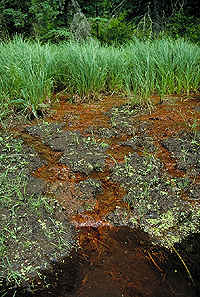
Brown, tea-stained spring water seeping into the Mississippi Headwaters indicates a high iron content.
Groundwater discharged along the edge of the river has very low dissolved oxygen, is colder than the surface water and has high iron content. Mooers' observations are supported by evidence of the Mississippi Headwaters River Watch program, which shows very low dissolved oxygen downstream of Itasca State Park.
Landform assemblages can be used for resource management by defining desirable locations for certain land uses. For example, for forest located on a hilly or morainal areas, the ratio of surface water runoff to ground water infiltration is very high. If such an area is harvested, contaminants will not easily enter the groundwater system, but will rapidly disperse into local wetlands and waterways. Such an area will have a low susceptibility to groundwater contamination but high probability for surface water contamination and siltation of wetlands by erosion.

MHB Publishes
Biennial Report
To The '97
Minnesota
Legislature
As mandated by Minnesota Statute 103F.361-378, the Mississippi Headwaters Board has made its eighth biennial report to the Minnesota Legislature. The report assesses the Board's progress in "protecting and enhancing the outstanding and unique values" of the Mississippi Headwaters.
In the past two years, the MHB has accomplished the following:
- Provided for consistent administration of land use rules in the Mississippi Headwaters corridor;
- Published information to assist private woodland owners with managing forest resources while protecting cultural resources, biological diversity and water quality; these materials include "how-to" guides for property owners and a data base of wildlife of the Mississippi Headwaters. The data base can be used to assess the relationship between a bird, mammal or amphibian and its habitat requirements.
- Extended River Watch water quality monitoring to 30 communities in the Mississippi's drainage;
- Developed curriculum materials to support use of River Watch in the classroom, and trained teachers at four workshops;
- Created an electronic network and data base for River Watch to help communities locate and monitor results;
- Directed River Defense Network activities, assessing the capacity of Mississippi River communities to protect the river and its resources from spills of hazardous materials.
For a copy of the MHB's biennial report to the 1997 Minnesota Legislature or for further information about the Mississippi River contact the Mississippi Headwaters Board at Phone: 218-547-7263, Fax: 218-547-7376
or E-Mail: 0999mhb@InforMNs.k12.mn.us.
Value Of Water Setback
Explored In Workshops
Maintaining a setback between water and development is the foundation of most shoreland protection ordinance, including the Mississippi Headwaters Ordinance.
Yet, many people involved in administration of shoreland zoning rules may not understand the values of that buffer between the shore and the building.
Each year, the Mississippi Headwaters Board hosts training for members of its eight county boards of adjustment and planning commissions, who administer the MHB's ordinance and management plan, in addition to county shoreland rules. In years past, these training workshops have covered legal and technical issues of zoning, such as how to create a findings of fact, or how to manage erosion in shoreland areas.
The Mississippi Headwaters Board's spring workshop for land use decision makers will answer the question of why this setback is necessary, and why it is important to shoreland protection. "People ask all the time, what's so important about being 150 feet from the water," said Paul Thiede, MHB Chairman. "This workshop will help members of county planning boards answer that question themselves," he said.
Staff of the Chippewa National Forest will lead the workshop using a riparian management manual they recently published. The Chippewa National Forest's Draft Riparian Manual explains the ecological functions of shoreland areas, which are highly productive areas for wildlife. Shoreland areas also protect water quality.
Workshops will include about two hours of classroom work in the morning and an equal amount of field work in the afternoon. Workshops will be hosted in two locations on the Mississippi River, at Itasca State Park and Crow Wing State Park. Scheduling will depend on spring thawing, and workshops are expected to occur in early May. Call the MHB office at 218/547-7263 to be advised of meeting locations and times.
Federal Dam Receives
State Wastewater Grant
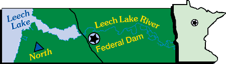
A new wastewater collection system will be built in Federal Dam, a tiny community with strong economic ties to the region's water quality. Cass County will receive a $1 million Small Cities Development Grant from the Minnesota Department of Trade and Economic Development to fix Federal Dam's wastewater problems.
Soils and elevations at Federal Dam, located where the Leech Lake River leaves Leech Lake, are not adequate for individual on-site sewage treatment. On-site systems did not function properly, and it was not unusual for wastewater to back out of systems and flow down the town's streets. Federal Dam is a popular destination spot for fishing and many of its residents work in tourism-related jobs. The Mississippi Headwaters Board responded to the requests from Cass County and the Tri-County Leech Lake Watershed Project to help make the case for correcting the problems.
An earlier application to the state was denied; however, political and financial support from the Board resulted in additional studies that enhanced the county's application.
"This is truly an accomplishment for Cass County," Governor Carlson said when he awarded the grant. "These funds are highly sought after, and competition among applicants is intense."
MHB Elects New Officers
Paul Thiede, Pequot Lakes,
has been elected Chairman of the Mississippi Headwaters Board. He is appointed to the MHB by the Crow Wing County Board of Commissioners, and is currently serving his third year with the MHB. He succeeds Ed DeLaHunt, Hubbard County. Margaret Sherman, Aitkin County, was elected Vice-Chair.
John Alden, Walker,
was elected Chairman of the MHB's Advisory Committee. The 34-member committee advises the MHB on policy issues. Alden is also President of the Ten Mile Lake Association. He succeeds Mark Jacobs, Assistant Land Commissioner for Aitkin County. Roger Boatman, Jacobson, was elected Vice-Chair.
| |